How was geography important in its development?
Geography played an important role in the shaping of the Mughal Empire. The area of land ruled over by the Mughals, was essentially split up into a couple different parts: the Indus river plains and river valley, the Ganges River plains and delta, the Deccan plateau, the east coast, and the west coast. These different regions that divide up the empire also divide up the religious cultural beliefs of the empire. Therefore geography was more than just where the empire was but, also who was where in the empire and how the emperor did unite them.
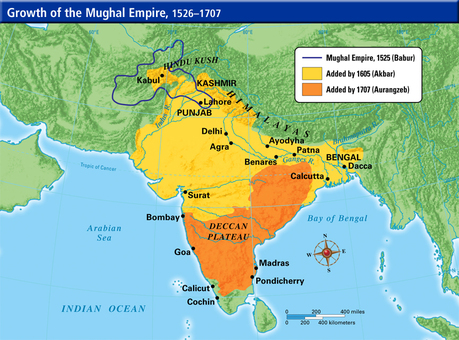
When Babur was founding the Mughal empire is when we first see geography as an important player in the empire’s development. To defeat the forces of the Delhi Sultans, Ibrahim Shah Lodi. Babur's army had to be mobile to move around and to surround the other forces. This was the main strategy of this battle and since panipat is mostly flat and full of plains there would be no place for ambush or even retreat. Yet, to solidify Babur’s rule in the indo-Afghanistan border region, he also had to capture cities near the Indus river plains. For example we can see on the map that Babur’s empire reached as far into central India as Lahore. This also set the stage for the further expansion into India by later rulers like Akbar and Alamgir.
After Babur’s son Humāyūn almost lost the whole empire, Akbar decided to expand much more into the Indus river valley, the Indus river plains, and the Ganges River plain, central India, and the Ganges river delta. The massive expansion meant that the Mughal Empire now had to accommodate for all the different types of peoples in the empire. So it is probable that some of the policies that Akbar implemented might not have been put in place if they hadn’t expanded as much. If we look at the things that Akbar did to change the empire most of them are equalize people and benefit the minority groups. For instance he abolished a tax on all non-Muslims and welcomed Hindus as equals in government. He also stabilized power of all these systems by implementing the mansabdari system, which put a check on every one, so the minorities could not unfairly take advantage of policies and the majority also couldn’t unfairly tax the minorities. Akbar also officially drew the line of the districts, provinces and cities in the empire, officially giving groups the land they deserved. So we can see how geography, effects the policy of some emperors, and the population of an empire.
Aurangzeb or Ālamgīr, who came much later than Akbar, expanded more on Akbar’s area of rule. He was a devout Muslim who made Islam the official religion of the Mughal empire, and wiped out all of Akbar’s tolerant policies on Hindus and minorities. He expanded a lot into the east and west coast of India, and the Deccan plateau. While Akbar knew these lands were occupied mostly by independent Hindu and Sikh groups, therefore he knew it would be hard to unite and control the empire if expanded into these regions. Ālamgīr had a different, view on this though he decided to violently expand, for 1.he hated Hindus, and 2.he wanted to monopolize on the trade cities and agricultural centers of India. Ālamgīr thought that Islam was the clear best religion and if you were anything but you were lesser than a Muslim, so when expanding into these territories was a good time to destroy Hindu temples and build mosques, effectively establishing power and religion in each city he conquered. But conquering these regions also gave him a geographical monopoly on Indian trade route and a monopolization of all agricultural land in the Deccan plateau. While these things boosted economy at the time, they didn’t matter in the end when the peoples of the Deccan plateau rebelled pushing the Mughal Empire into one small area of central India and started the downfall of the Mughal Empire as a whole. Showing us again how important geography is to the unity of an empire and the power that comes from that unity or the absence of that unity.
by: Philip Harder
